The Bird's-Eye View: A Look at the Global Aerial Survey Service Industry

In a world where data is the new oil, the ability to rapidly and accurately capture information about the Earth's surface is a capability of immense value. This is the domain of the aerial survey service market, a dynamic and technologically advanced industry dedicated to acquiring geospatial data from an airborne perspective. This industry uses a variety of aircraft, from traditional fixed-wing planes and helicopters to, increasingly, unmanned aerial vehicles (UAVs or drones), equipped with sophisticated sensor payloads to map, measure, and monitor the physical world below. A comprehensive examination of the Aerial Survey Service Market industry reveals a sector that provides the foundational data for a vast range of applications, including urban planning, infrastructure management, agricultural monitoring, environmental protection, and resource exploration. By providing a detailed, accurate, and up-to-date "digital twin" of the real world, aerial survey services empower governments, businesses, and scientists to make more informed decisions, manage resources more effectively, and respond more quickly to a changing world. It is the industry that provides the critical context of "where" to a vast array of economic and scientific activities.
The core of the aerial survey service industry is the data acquisition process. This involves meticulously planning and executing a flight mission over a specific area of interest. The aircraft flies a series of precise, overlapping flight lines, with the onboard sensors continuously collecting data. There are several key sensor technologies used. The most common is high-resolution digital aerial photography, which captures detailed visual images of the ground. These overlapping images can then be processed using a technique called photogrammetry to create highly accurate orthophotos (geometrically corrected images that are true to scale) and 3D digital surface models. Another critical technology is LiDAR (Light Detection and Ranging). A LiDAR sensor emits rapid pulses of laser light and measures the time it takes for the pulses to reflect off the ground and return. This allows for the creation of an incredibly dense and accurate 3D point cloud of the terrain and any objects on it, capable of "seeing" through vegetation to map the bare earth below. Other specialized sensors include thermal cameras for detecting heat signatures and hyperspectral imagers for identifying different materials based on their unique spectral properties.
The industry ecosystem is a diverse mix of specialized service providers, hardware manufacturers, and software developers. The service providers are the companies that own and operate the aircraft and sensors and employ the skilled pilots, sensor operators, and data processors. These range from large, multinational surveying and mapping companies to smaller, regional firms, and a rapidly growing number of drone service providers. The hardware manufacturers produce the key enabling technologies, including the aircraft themselves, the survey-grade digital cameras, the LiDAR systems, and the high-precision GPS and inertial measurement units (IMUs) that are essential for accurately georeferencing the collected data. The software developers create the powerful software platforms used for flight planning, processing the raw sensor data, and analyzing and visualizing the final geospatial products. This includes photogrammetry software, LiDAR processing software, and Geographic Information System (GIS) platforms that are used to manage and interpret the final data products.
The applications and end-users of aerial survey services are vast and span nearly every sector of the economy. Government agencies are major customers, using aerial survey data for national mapping programs, transportation planning, disaster response (e.g., mapping flood inundation), and environmental monitoring. The construction and engineering industries rely heavily on aerial surveys for site selection, topographic mapping for design, and monitoring the progress of large infrastructure projects like highways and pipelines. In the energy and mining sectors, aerial surveys are used for resource exploration, volume calculations of stockpiles, and monitoring the safety and integrity of infrastructure. The agriculture industry is a rapidly growing user, employing aerial survey data (often from drones) for precision farming, where it is used to monitor crop health, assess irrigation needs, and optimize the application of fertilizers. This broad and expanding range of use cases demonstrates the fundamental utility of high-quality geospatial data and is a key driver of the industry's sustained importance and growth.
Top Trending Reports:
الأقسام
إقرأ المزيد
In today’s global world, learning a foreign language has become more than just a hobby. French is one of the most widely spoken languages across the world and is used in international business, education, tourism, and diplomacy. Because of this growing importance, many students and professionals are choosing online learning platforms to improve their language skills. An online French...
Турнирным оператором сезона Mobile Legends: Bang Bang в СНГ выступит компания Electronic Mushroom – партнер разработчика Moonton в регионе с 2019 года. Сезон организован по трехдивизионной системе: регулярные рейтинговые турниры, любительская лига и профессиональная лига. Эта структура предоставляет командам прозрачный путь от любительских матчей до международной арены. Структура сезона...

In today’s fast-paced lifestyle, many people in Dubai are looking for safe and convenient ways to reduce stubborn fat without going through surgery. Fat melting injection in Dubai has become one of the most popular aesthetic treatments for individuals who want to enhance their body shape with minimal downtime and natural-looking results. Whether it’s unwanted fat around the abdomen,...

Ma Basket De Sécurité propose une basket de sécurité moderne et protectrice : la Guyisa Titan, une chaussure de sécurité légère avec coque antichoc, semelle antidérapante et tissu respirant. Le basket de sécurité, également connu sous le nom de chaussures de sécurité ou de baskets...

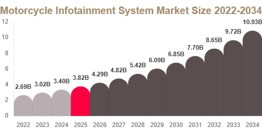
Motorcycle Infotainment System Market Size The Motorcycle Infotainment System market size was valued at USD 3.84 billion in 2025 and is projected to reach USD 4.29 billion in 2026. By 2034, the market is expected to attain USD 10.92 billion, registering a CAGR of 12.4% during 2025–2034. Get Your Sample Report Here:...