


Mapping and Data Services That Actually Work in the Field
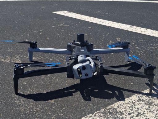
Mapping and data services used to feel like something only big agencies could afford. Expensive rigs. Closed software. Long timelines. Then drones showed up and kind of wrecked that old setup. In a good way. Now, teams can run aerial mapping on a Tuesday and make decisions by Thursday. I’ve watched site managers pull up drone mapping results on a tablet, right there in the dust, and change a plan on the spot. No ceremony. No waiting on a report that lands a month late. Drones for Mapping didn’t just speed things up. They changed the pace of work. The work itself feels more alive now, more responsive. You see the terrain as it is, not how it was.
Drone Mapping Isn’t Magic, It’s Work
Let’s be honest. Drone mapping isn’t some push-button miracle. You still need a plan, clean flight paths, good ground control, and someone who knows how to process the data without breaking it. But when it’s done right, the output is solid. Orthos that line up. Models that don’t wobble. Real measurements you can trust. Aerial Mapping helps you catch grading mistakes early. You spot drainage issues before the rain finds them for you. I’ve seen small survey teams do more in a day than they used to in a week, just by leaning into mapping and data services that fit the job instead of forcing the job to fit the tool.
Where Security Drones Fit Into the Picture
Security Drones get talked about like they’re only for guarding fences at night. That’s part of it, sure. But they also feed the same mapping and data services pipeline. A perimeter flight at dusk can double as an updated site map. That overlap matters. When security and mapping share the same sky, you get fewer blind spots. You also get better context when something goes wrong. A weird vehicle track shows up? Pull the drone mapping archive. See when it appeared. Security Drones, when used smart, aren’t just eyes. They’re memory. A living record of what changed, when it changed.
The Data Is Only Useful If You Can Read It
Here’s the blunt part. Tons of people collect data they don’t know how to use. They fly. They map. They store terabytes. Then it sits. Mapping and data services only matter if the output is readable to the people making calls. Foremen don’t want a dense GIS interface at 6 a.m. They want a clean image that shows where the trench drifted. Aerial Mapping needs to meet the field where it is. Not the other way around. The best drone mapping setups I’ve seen come with simple viewers, quick exports, and just enough context to act. Not a data dump. A nudge toward the next move.
Real-World Wins You Don’t See in Brochures
Nobody puts the boring wins in the brochure. But that’s where mapping and data services shine. Catching a stockpile count before materials go missing. Verifying a slope before someone sends equipment into a bad spot. Security Drones doing a quiet sweep after hours and flagging a gate that didn’t close all the way. These aren’t headline moments. They’re the small saves that add up. Drones for Mapping make it easier to notice stuff you’d otherwise miss because you’re tired, or rushed, or just human. And yeah, we all are.
The Messy Side of Flying in the Real World
Weather doesn’t care about your schedule. Wind messes with your lines. Dust sneaks into sensors. Batteries lie about how full they are. This is where the talk of mapping and data services gets real. You plan for bad data days. You build in re-flights. You accept that drone mapping sometimes means waiting an extra hour for the light to soften. Security Drones have it rough too. Night flights aren’t forgiving. Shadows trick cameras. You learn to live with the mess. And when the data comes back clean anyway, it feels earned.
Getting Buy-In From Teams Who Hate New Tools
Some crews don’t trust drones. They’ve been burned by half-baked tech before. Fair. The trick is showing how mapping and data services help them today, not someday. Show a side-by-side. Old survey vs Aerial Mapping. Point to the cut that was off, now fixed. Let security teams see how Security Drones shorten their patrols and still catch more. Keep it simple. No hype. Once people see drone mapping saving them steps, they usually come around. Not all at once. But enough.
Conclusion: Build the System, Not Just the Flight
If you take one thing from this, let it be this. Mapping and data services aren’t about flying drones. They’re about building a system people actually use. Aerial Mapping feeds decisions. Drone mapping feeds trust. Security Drones feed awareness. When those pieces line up, the tech fades into the background and the work gets clearer. Not perfect. Clearer. And that’s enough to move faster without tripping over your own data.
Categorie
Leggi tutto
" According to the latest report published by Data Bridge Market Research, the Adaptogenic Beverages Market The global adaptogenic beverages market size was valued at USD 1.47 billion in 2025 and is expected to reach USD 2.52 billion by 2033, at a CAGR of 6.97% during the forecast period The market growth is largely fueled by rising consumer preference...
Weekends are a special time to slow down, breathe deeply, and reconnect with peace and gratitude. After a long week filled with work, responsibilities, and stress, the weekend gives us a chance to refresh our hearts and minds. This is why charm blessings have become a beautiful source of encouragement for people seeking joy, faith, and positivity in daily life. Whether you begin your day...

Every marketer has heard it a dozen times: "Content is king." But content without distribution? That's just words sitting in a corner. The real power shows up when your content appears on the right websites, in front of the right readers, with a link pointing back to you. That's exactly where guest posting earns its place. What Is Guest Posting? At its core, guest posting means writing an...
Executive Summary Private Label Food and Beverage Market Value, Size, Share and Projections Global private label food and beverage market size was valued at USD 9.92 billion in 2024 and is projected to reach USD 16.41 billion by 2032, with a CAGR of 6.5% during the forecast period of 2025 to 2032. The world class Private Label Food and Beverage Market research report is a...
In the present day digitalized and busy world, agencies are pressured to perform and handle numerous clients simultaneously. Increasing operations without overstraining internal teams may be a challenge. It is at this point that the services of SEO resellers come in. Through a trusted partner, agencies are able to provide full SEO solutions on their brand name whilst conserving time, effort,...