Flooding is one of the most significant natural hazards affecting communities around the world. As climate patterns shift and urban areas expand, the need for thoughtful, evidence-based planning has never been greater. A flood risk assessment for planning is a critical tool in this process, ensuring that new developments are safe, sustainable, and resilient. Far more than a bureaucratic requirement, an FRA provides a comprehensive understanding of how water behaves across landscapes and how built environments can coexist with natural hydrological systems.
In modern planning, flood risk assessment stands at the intersection of engineering, environmental science, architecture, and public policy. It supports informed decision-making, protects lives and property, and shapes long-term development strategies that respond to the realities of a changing climate.
Understanding Flood Risk in the Planning Context
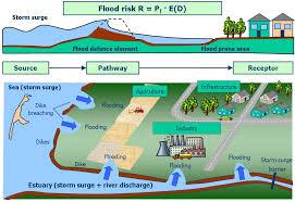
Flood risk is typically defined as the combination of the probability of flooding and the potential consequences if flooding occurs. In planning terms, this means evaluating not just whether a site might flood, but how severe the impacts could be on people, infrastructure, and the environment.
Flooding can arise from multiple sources: river (fluvial) flooding, surface water (pluvial) flooding, coastal flooding, groundwater flooding, reservoir or infrastructure failure, and sewer surcharge. A thorough flood risk assessment must consider all these possibilities. Overlooking even one source can leave developments vulnerable.
Planning authorities require FRAs to ensure that development does not increase flood risk elsewhere and that new structures are safe for their intended lifetime. This is particularly important in low-lying regions, near rivers, or in urban areas with limited drainage capacity. An effective FRA identifies risks early, allowing designers to adapt proposals before construction begins.
The Purpose and Importance of a Flood Risk Assessment
The primary goal of a flood risk assessment is to evaluate the likelihood and consequences of flooding for a specific site and to recommend measures to mitigate those risks. However, its broader importance lies in sustainable land management.
Without careful assessment, developments can disrupt natural drainage patterns, increase surface runoff, and worsen downstream flooding. By understanding how water flows across and through a site, planners can incorporate measures that maintain or even improve existing conditions.
In many countries, planning frameworks require a sequential approach—prioritizing development in areas of lowest flood risk before considering higher-risk zones. When development in higher-risk areas is unavoidable, an FRA ensures that appropriate design and mitigation strategies are in place.
Beyond regulatory compliance, flood risk assessments offer economic benefits. Flood damage can lead to costly repairs, insurance complications, business interruption, and reputational harm. Investing in a comprehensive FRA at the planning stage can prevent far greater losses in the future.
Key Components of a Comprehensive Flood Risk Assessment
A well-prepared flood risk assessment includes several essential elements. Each component contributes to a holistic understanding of the site’s vulnerability and resilience.
1. Site Description and Context
The assessment begins with a detailed description of the site, including its location, size, topography, geology, and current land use. Planners examine historical flood records, existing flood maps, and nearby watercourses. The surrounding catchment area is also analyzed to understand upstream and downstream influences.
Topographical surveys play a crucial role here. Even small changes in ground level can significantly influence flood pathways and storage capacity.
2. Identification of Flood Sources
The next step is identifying all potential sources of flooding. River proximity, local drainage systems, groundwater levels, and coastal influences must be evaluated. Surface water flooding is particularly important in urban environments, where impermeable surfaces such as roads and roofs prevent natural infiltration.
Hydrological and hydraulic modeling is often used to simulate flood events under different scenarios, including extreme rainfall events and climate change projections.
3. Climate Change Considerations
Climate change is altering rainfall intensity, sea levels, and storm patterns. A forward-looking FRA must account for projected increases in rainfall and river flows over the lifespan of the development. Ignoring climate projections can lead to under-designed mitigation measures and future vulnerability.
Design allowances for climate change typically include increased peak river flows and rainfall intensities. By incorporating these factors, developments remain resilient not just today, but decades into the future.
4. Assessment of Flood Consequences
Risk is not only about probability; it is also about impact. An FRA evaluates the potential depth, velocity, and duration of floodwaters on the site. These factors determine the level of hazard to occupants and structures.
For example, shallow, slow-moving water may pose less danger than deep, fast-flowing currents. Understanding these characteristics informs building design, access routes, and emergency planning.
5. Mitigation and Management Measures
Once risks are identified, the assessment proposes measures to reduce or manage them. These can include:
-
Raising finished floor levels above predicted flood levels
-
Incorporating flood-resistant or flood-resilient materials
-
Designing safe access and egress routes
-
Installing sustainable drainage systems (SuDS)
-
Preserving or enhancing natural floodplains
The objective is to ensure that the development remains safe without displacing flood risk onto neighboring areas.
Sustainable Drainage Systems: A Modern Approach to Water Management
Sustainable Drainage Systems (SuDS) are increasingly central to flood risk management in planning. Instead of channeling rainwater quickly into pipes and sewers, SuDS aim to mimic natural processes by slowing, storing, and filtering runoff.
Examples include permeable paving, green roofs, detention basins, swales, and rain gardens. These features reduce peak flow rates, improve water quality, and enhance biodiversity. In addition to mitigating flood risk, they create attractive landscapes and contribute to environmental sustainability.
Integrating SuDS into a development’s design from the outset is far more effective than retrofitting solutions later. An FRA often serves as the foundation for a comprehensive drainage strategy that aligns engineering performance with ecological benefits.
Sequential and Exception Approaches in Planning Policy
Planning authorities often apply a sequential approach to development. This means directing new construction to areas with the lowest probability of flooding. Only when there are no suitable alternatives should development be considered in higher-risk zones.
In certain circumstances, an exception test may be applied. This requires demonstrating that the development provides wider sustainability benefits that outweigh flood risk and that it can be made safe for its lifetime without increasing risk elsewhere.
Tree Survey Reports are central to both approaches. They provide the evidence base required for planners to make informed, transparent decisions that balance growth with safety.
Designing for Resilience and Adaptation
Flood risk assessment is not merely about avoiding water; it is about adapting intelligently to it. In some locations, complete avoidance may not be possible or practical. In such cases, resilient design becomes essential.
Flood-resilient buildings are designed to withstand inundation with minimal damage and rapid recovery. This may involve using water-resistant materials, locating electrical systems above predicted flood levels, and incorporating demountable flood barriers.
Urban design also plays a role. Open spaces can double as temporary flood storage areas, while streets can be shaped to channel excess water safely. By embracing water-sensitive design principles, developments can transform potential hazards into manageable features.
The Role of Professional Expertise
Preparing a robust flood risk assessment requires multidisciplinary expertise. Hydrologists, civil engineers, environmental consultants, and planning specialists collaborate to analyze data, model scenarios, and develop practical solutions.
Accurate data collection and modeling are critical. Advances in geographic information systems (GIS), remote sensing, and hydraulic simulation software have significantly improved the precision of flood risk predictions. However, professional judgment remains essential in interpreting results and recommending appropriate measures.
Engaging experienced professionals early in the planning process can streamline approvals and reduce costly redesigns.
Community Safety and Long-Term Sustainability
At its core, flood risk assessment is about protecting communities. Poorly planned development can have devastating consequences, not only for residents but also for emergency services and public infrastructure.
By ensuring that developments are safe, accessible, and resilient, FRAs contribute to broader sustainability goals. They support climate adaptation strategies, protect natural ecosystems, and reduce long-term economic losses.
Incorporating community engagement into the planning process can further strengthen outcomes. Local knowledge of past flood events can provide valuable insights that complement technical data.
Future Challenges in Flood Risk Management
As urbanization accelerates and climate uncertainties grow, flood risk management will become even more complex. Increasingly intense rainfall events and rising sea levels demand adaptive, forward-thinking approaches.
Emerging technologies, such as real-time flood monitoring and advanced predictive modeling, will enhance assessment capabilities. However, successful flood risk management will also depend on integrated policy frameworks and collaboration across sectors.
Developers, planners, policymakers, and communities must work together to create resilient environments that respect natural water systems.
Planning with Water, Not Against It
Flood risk assessment for planning is a fundamental pillar of responsible development. It ensures that growth does not come at the expense of safety or environmental integrity. By carefully analyzing flood sources, modeling future scenarios, and implementing thoughtful mitigation measures, planners can reduce vulnerability and enhance resilience.
Rather than viewing flood risk assessment as a constraint, it should be embraced as an opportunity—to design smarter, build stronger, and create places that thrive even in the face of uncertainty. In an era defined by climate change and rapid urban expansion, planning with water in mind is not optional; it is essential for sustainable progress.