


Exploring the Geography and Landscapes of North Africa’s Iconic Mountain Range
The Atlas Mountains stretch across North Africa like a natural backbone, offering breathtaking landscapes, diverse ecosystems, and rich cultural history. Understanding this vast mountain system becomes much easier when you explore an atlas mountains map, which visually connects its regions, peaks, and surrounding areas. Whether you're a traveler, researcher, or geography enthusiast, mapping out this region provides clarity on its structure and significance.
Overview of the Atlas Mountain System
The Atlas Mountains extend over approximately 2,500 kilometers across Morocco, Algeria, and Tunisia. These mountains form a natural barrier between the Mediterranean and Atlantic coastlines and the Sahara Desert. The range is not a single continuous line but rather a complex system divided into several sub-ranges, each with unique characteristics.
The main divisions include the High Atlas, Middle Atlas, Anti-Atlas, and the Tell Atlas. Each of these sections plays a role in shaping the climate, biodiversity, and human settlement patterns of the region.
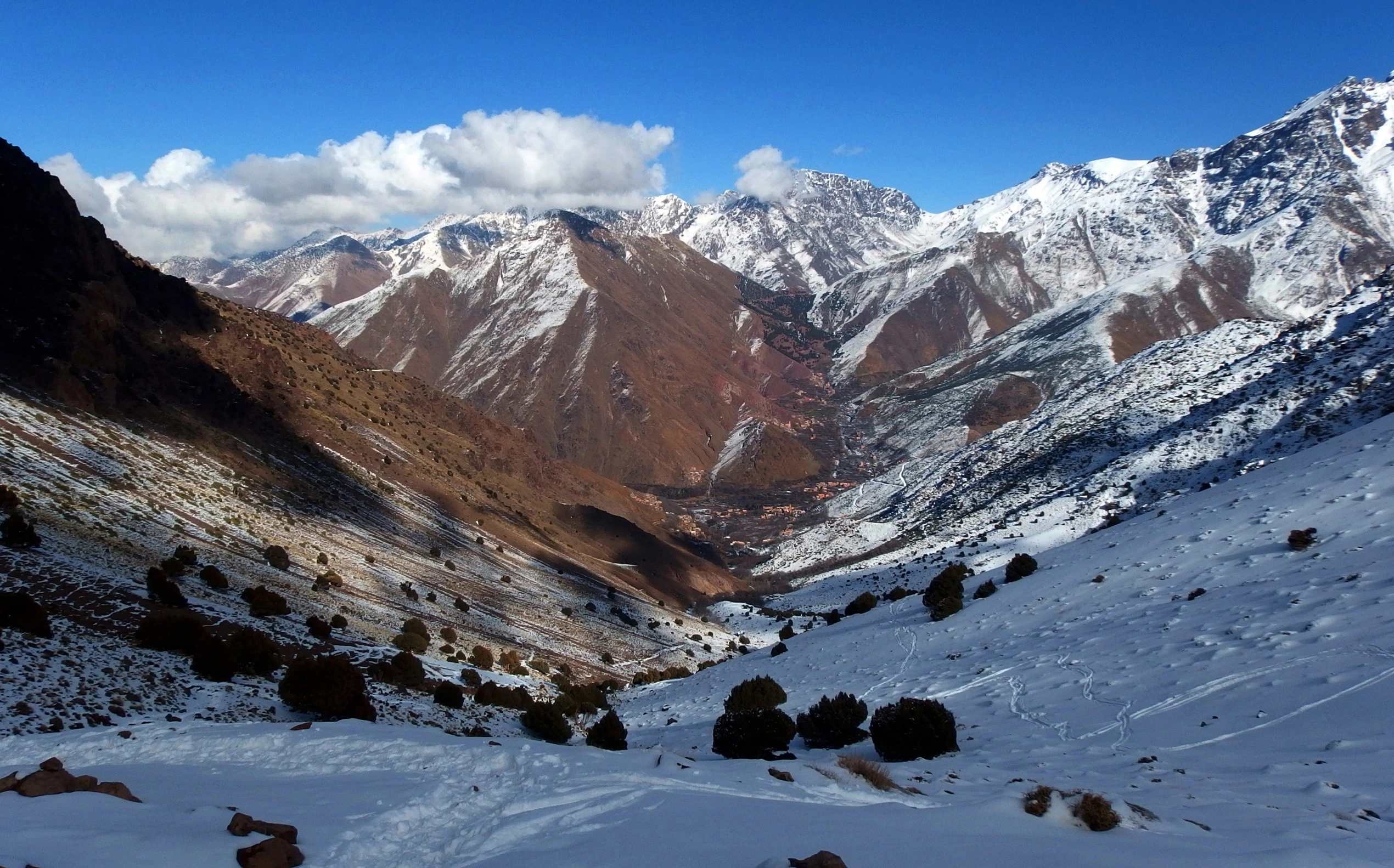
Importance of Mapping the Region
Using an atlas mountains map allows you to better understand how these ranges are distributed geographically. It highlights elevation differences, key cities, trekking routes, and natural landmarks. Maps also help identify major peaks such as Mount Toubkal, the highest point in North Africa, standing at 4,167 meters.
For travelers and hikers, maps are essential tools for planning routes, understanding terrain difficulty, and ensuring safety. For students and researchers, they provide insight into geological formations and tectonic activity.
Major Sub-Ranges Explained
High Atlas
The High Atlas is the most prominent and highest section of the mountain system, located primarily in Morocco. It includes dramatic peaks, deep valleys, and remote Berber villages. When viewing this section on a map, you’ll notice how it runs diagonally across the country, separating the Atlantic coast from the Sahara.
Middle Atlas
Located north of the High Atlas, the Middle Atlas features more moderate elevations and lush forests. This region is known for cedar trees and wildlife, including Barbary macaques. Maps often show this area as greener compared to the more rugged High Atlas.
Anti-Atlas
The Anti-Atlas lies south of the High Atlas and is characterized by older, eroded mountains. It appears less elevated on maps but is rich in geological history and mineral resources.
Tell Atlas
Stretching through northern Algeria and Tunisia, the Tell Atlas runs parallel to the Mediterranean coast. It plays a key role in agriculture due to its relatively fertile land.
Geographic Features Visible on Maps
An atlas mountains map reveals several key geographic features:
- Peaks and Elevation Levels: Identifying the highest points and elevation gradients
- Rivers and Valleys: Important water sources and fertile areas
- Desert Boundaries: Transition zones between mountains and the Sahara
- Cities and Villages: Human settlements adapted to mountainous terrain
These elements help users understand how geography influences life in the region.
Climate and Environmental Impact
The Atlas Mountains significantly affect regional climate patterns. They act as a barrier that traps moisture on the northern side, leading to greener landscapes, while the southern side remains dry and arid.
Maps often illustrate these climatic differences through vegetation patterns. Northern slopes appear greener, while southern areas transition into desert tones. This contrast is crucial for agriculture, water supply, and biodiversity.
Cultural and Historical Significance
The mountains are home to Berber communities who have lived there for centuries. Mapping these مناطق (regions) helps highlight cultural distribution, trade routes, and historical pathways.
Traditional villages are often located in valleys or along mountain slopes, which can be clearly seen when analyzing a detailed map. These settlements reflect a deep connection between people and the land.
Travel and Trekking Insights
For adventurers, studying an atlas mountains map is the first step in planning a journey. Popular trekking routes, including those leading to Mount Toubkal, are clearly marked in many maps.
Tour companies like mttoubkaltrek offer guided experiences that rely heavily on accurate mapping to ensure safe and enjoyable trips. These maps include trail difficulty, elevation gain, and rest points, making them essential for hikers.
Digital vs Physical Maps
Today, travelers have access to both digital and physical maps. Digital maps offer GPS tracking, real-time updates, and interactive features, while physical maps provide reliability in areas with no signal.
Using both types together can enhance navigation and preparedness, especially in remote mountainous regions.
Geological Formation
The Atlas Mountains were formed due to tectonic activity caused by the collision of the African and Eurasian plates. This process created folds and faults that are still visible today.
Maps that focus on geology show rock types, fault lines, and seismic activity zones. These are useful for researchers studying Earth’s structure and history.
Wildlife and Natural Resources
Mapping also helps identify areas rich in biodiversity. Forest zones, wildlife habitats, and protected areas are often marked clearly.
The region is home to various species, including birds, mammals, and reptiles adapted to mountainous environments. Natural resources such as minerals are also distributed across different parts of the range.
Practical Uses of Maps
An atlas mountains map serves multiple purposes:
- Travel planning
- Educational research
- Environmental studies
- Cultural exploration
It simplifies complex geography into an easy-to-understand visual format.
Conclusion
The Atlas Mountains are more than just a physical feature; they are a vital part of North Africa’s identity. From influencing climate to shaping cultures, their importance cannot be overstated. Exploring this region through a map provides a deeper understanding of its complexity and beauty.
Whether you're planning a trek, studying geography, or simply curious about the world, taking the time to examine these mountains through mapping will greatly enhance your knowledge and appreciation.
Categorias
Leia mais
Data Bridge Market Research analyses that the preimplantation genetic screening (PGS) technology market which was USD 552.50 million in 2021, would rocket up to USD 1228.09 million by 2029, and is expected to undergo a CAGR of 10.50% during the forecast period 2022 to 2029. The global business landscape is undergoing a transformation, with industries increasingly leaning on deep research and...
HelloDumps offers the latest F5 F5CAB1 exam questions with 90 days of free updates. Trusted study material, instant access, and a 25% OFF deal to help you pass quickly. Clear Your F5 F5CAB1 Exam Faster – Get 25% OFF on HelloDumps! Don’t waste hours searching for reliable study material. HelloDumps gives you verified F5CAB1 exam questions designed to help you pass...

Valorant’s latest patch, 12.05, brought significant changes to several agents, but none drew more attention than the adjustments to Clove. Coleman Palm, Valorant’s product lead, acknowledged that Clove had become “too powerful overall,” prompting a targeted nerf aimed at reducing the agent’s post-death smoke capabilities. The developer explained that Clove’s...

There is a great deal of urgency in the modern medical field, with precision and rapid response being essential particularly in laboratory work. The slightest mistakes in the laboratory reports may result in wrong diagnoses, later treatments, and lack of patient confidence. It is here a Laboratory Information Management System (LIMS) comes in to play a crucial role. Modern lims software will...

Polaris Market Research has introduced the latest market research report titled Intraoperative Imaging Market Share, Size, Trends, Industry Analysis Report, By Product (X-ray, C-arms, Intraoperative Ultrasound); By Application; By End-User; By Region; Segment Forecast, 2024 - 2032 that highlights the major revenue stream for the forecast period. The report contains clear, reliable,...